[5] Atlas of Kharak – Tiir’s location

The city model is coming along but I have a little snippet from some poking around of Kharak’s texture map. I wanted to place Tiir itself.

Tiir’s location was originally stated in the Homeworld 1 manual to be in a canyon “blasted into the side of Kharak’s tiny ice cap”. However, in one cutscene Deserts of Kharak places Tiir well and away from the polar ice caps… actually close enough to the deserts for the Gaalsien to threaten it. In fact, it’s not even close to the caps to really explain the polar ice caps retreating since the foundation of the city… since that would presume the icecaps at one time nearly covered the northern hemisphere.

But let’s not get judgemental over details shall we? Besides, I’m going out of my way to look for things that might not look good under close scrutiny. There will be errors, just like the Homeworld 1 region maps don’t line up to the strategic map. I’ll think up a plausible reason for Tiir’s placement when it comes to creating the written content for this Atlas of Kharak, should I get to that step.

Back to the point. Tiir was defined in Deserts of Kharak in one cutscene that names a few locations in the northern Coalition (along with the Frontier Wall and frontier bases, but no other cities). It is easily found afterward because it has the largest sensor dome of all the northern habitats.

I picked one of the screencaps I had of this cutscene and decided to do some image enhancing in photoshop. Soon I was able to spot some latitude and longitude lines. Through it I was able to pick out where I presume Tiir is located:

TiirPlace

It’s somehwere within that isthmus along what seem to be fertile vallies now. Perhaps the Naabal hid away in this valley while the strife was going on all around them. I don’t think aircraft were an invention during the Heresy wars (if anyone had them, it was Naabal or Sjet), so it would be easily overlooked to travellers on foot.

Part of the reason I looked into this was because I wondered if I should include cliffs in the map of Tiir. The snapshots that we have don’t show an obvious sign of immediate mountains, so it must be wide enough of a valley for the cliffsides to be lost in the distance. That, or Tiir’s “camera” is aimed away from the walls. Yet we can see the Scaffold fly overhead to give us some idea of where that camera is oriented. It appears, after all, that Kharak’s sun sets in the east. Noticed that detail as Kapisi was leaving their base in mission 1, headed east, into a sunset as they traveled to the Boneyard.


[5] Atlas of Kharak – Tiir’s location

[4] Atlas of Kharak – Named Places

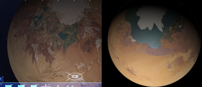
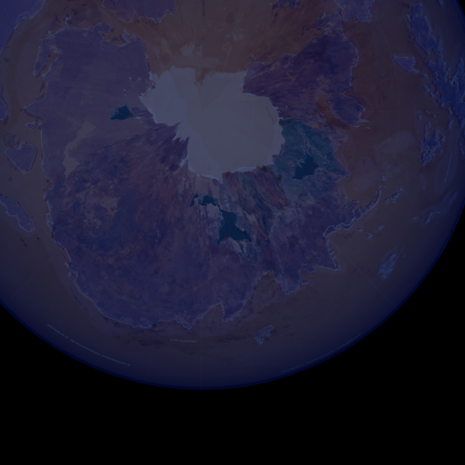
Progress on the main map was held up by going through the manuals from Homeworld 1 and Catalcysm to find out all the known places on Kharak and catalogue them. From there, I’ll start to place them on the best physical map we have of Kharak (which I now have! Thanks BBI!)

Might as well list out what I have:

————————-

Homeworld 1 Manual

The Three Northern Seas: One of these, and the largest in the north, is the Salt Sea.

Great Majirian Ocean, Majiirian Sea: The Great Grey Sea, the southern expanse and bounty of the Paktu people. Largest sea-mass on the planet.

Saju-Ka: The artistic gem of Kharak at the time. Contains the most greatest work commissioned in the name of Sajuuk. Every library contained the collective works of the Kushan people. The city would have been swallowed by sand in the early 700s if it were not for the great engineer Gar Nabaal’s network of works. Destroyed in 717

Paktu: Origins were slopes above the salt sea in 462. In 488 they were dispossessed.

The Plain at Albegiido: 490 KDS, the Paktu depart and set sail into the great banded desert on the winds of the seasonal storm, the Chak M’hot.

Hunon Mountains: Paktu lost many members crossing the pass to poisonous water, lizardbite, and rockfall.

Burning Red Canyons of the Hunon: The people despaired, but Paktu then saw a white sea-spirit on the horizon.

The Great Banded Desert: The central desert that rings the planet.

The Southern Federation: Paktu?

The Second Sea: lands on the coast were the origin of the Soban. (Saabel?) Not a blade of grass was left green… the land was green.

The Sparkling Desert: a location beside the Second Sea. Soban desired to lead troops across this body to attack the invaders of their old homelands.

Tiir: Fled from Gaalsien to their hidden valley refuge, blasted into the edge of Khark’s tiny northern icecap

White Desert: 340, along the shores of this desert, is the first mention of the Manaani as “raiders”. There is a “waterside” here.

Ferin Sha: The dancing ground. Nearly 200 miles from the White Desert. Last celebration here was in 513, where the Siidim attacked it with an army.

Cataclysm Manual

Kohntala Mountain Range: Ancestral homes of the Somtaaw. Varied from Fams, dams, and mills, to fortresses and towns. More than self-sufficient of a Kiithid here. Natural barrier between the Siidim and Gaalsien.

  • Hameln: Walled city of the Somtaaw. Source of the smelters for ore from the Red Creek Valley.
  • Gydeo: Walled city of the Somtaaw. Dome of Heaven is located here.

Lungma Jiin: Roof of the world, the highest known mountain on Kharak at the time.

  • The Shimmering Path: 33 temples. Each more inaccessable than the last. The path was closed to outsiders 300 years before the discovery of the Guidestone. Still closed by the burning of Kharak. 675 all but the Oracle of Tala and the Dome of heaven were closed to outsiders.
  • Oracle of Tala: First temple on the Shimmering Path
  • Dome of Heaven: Seventh Temple, most Kharakid ended their pilgrimage here. 26 more temples up.
  • Kuun-Lan: “Purifying Flame”
  • Faal-Corum “Silent Wayfarer”
  • Clee-San “ Truth Seeker”
  • ? Teer-Gig:
  • ? Gaal-Ten
  • ? Coor-Lan
  • ? Naab-Corum
  • ? Toet-Coy
  • ? Eheb-San
  • ? Shuus-nan
  • ? Thuuw-Nan
  • ? Morrh-Re
  • ? Ruun-Aaid
  • ? Shin-Clah
  • ? Baar-Ett
  • ? Gaar-Balhi
  • ? Vhenk-Maan
  • ? Maal-Nitz
  • ? Feng-Yuun
  • ? Thul-Lee
  • ? Mholah-Ri
  • ? Veer-Kah
  • ? Eh-Ghoan
  • ? Drun-Kyori -27 names including the three canonical ones in the lore
  • Temple of the Mysteries: Highest of the Temples. Upper slopes of Lungma Jiin, a blasted ladder of crumbling granite and thin ice and constantly buffeted by freezing gale force winds.
  • Kasar Road: Only way into Somtaaw holdings.
  • Red Creek Valley: Source of Iron found in the mountain ranges. Bounty of Kuura.

Kasar Desert: At the foot of Lungma Jiin and at the start of the Shimmering Path.

———————

Those who have known me from the Relicnews forums will remember my distaste for Cataclysm’s contributions to the lore, but I find nowadays that I treat it as apocraphal. I’ll take what I want from it and leave the rest as conjecture. BBI has adopted the portion of the lore pertaining to Kharak for the expedition guide, so there’s no reason not to treat it as canon as well.

The long list of names preceeded by ? are all the selection-names from the Motherships and Carriers in Catalcysm (there you could select the names of your ships in your skirmish battles). As the three ships named in Cataclysm were names of temples along the shimmering path, it makes sense that the other names may be other names of those temples as well. Including the three ships, there are 24 names, out of 33 temples. In absence of other information, sure! Why not adopt them as other names for those temples.

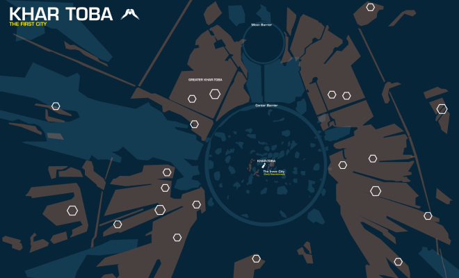
Now I need to find a home for them.

TopTactical

This is the home of the Northern Coalition, and presumably the largest habitable landmass that the Kharakid call home. This is probably the battle ground between the Siidim and the Gaalsien in the heresy wars. Somewhere in here I need to find Lungma Jiin, part of the Kohntala Mountain Range, and with feet at the Kasar desert. Between that are the land-holdings of the Siidim and Gaalsien.

[4] Atlas of Kharak – Named Places

[3] Atlas of Kharak – Tiir

Even though I just got a hold of some REALLY GOOD assets for the map of Kharak, for some reason I want to take a sidestep since i got a spontaneous vision and wanted to work on it some.

To get some background for this, a little while ago I ran across an interesting looking map:

space-city-large-copy


It’s from Halo obviously, probably the city of reach. The link where I found this seems to say the original artist was Liam Keating, for the Starside Intercept mod for Homeworld 2. I like the style of it, simple polygons just to describe the shapes of the city with lined call-outs to say what they were. It reminded me of another map source I had when I was a kid:

712hwbfzrdl

This is from “The Picture Atlas of the World” from 1998. I had one as a kid since my mom worked for Discovery Toys for a while and got one for us. The city call outs really came to mind, and though I can’t seem to find my version of the book, this works just as well to remind me of how the maps worked.

Needless to say these ideas combined made me think I could probably try to model the capital city of Tiir, to at least present some kind of representation of the city. It would be a necessary addition to the atlas of the planet, no?

Research for Tiir itself isn’t hard, since there aren’t a lot of times Tiir itself is depicted. The first time we see Tiir (as an unnamed Kharak city, but most likely the planetary capital) is during the intro cinematic of Homeworld 1 showing the scaffolding under construction, and again when the city is destroyed by the Taiidan ADWs.

Tiir isn’t depicted in Cataclysm, but we have a re-draw of the city coming out of Homeworld: Remastered, which (I checked) was re-used for Deserts of Kharak with some lighting changes and the like. Here’s a good comparison of HW1 and HWR/DoK’s differences, slight as some might see them:

ixjjptg


The greatest change is the massive dome in the background. I think its safe to call this the Daiamid’s council chambers, since it’s big and important. I keep wanting to call the foreground dome either the ministry of defense, or ministry of spaceflight, because this is Homeworld and spaceflight is just as important. The Dome has clearly gone through some changes, going from the tapered bowl-shape to a definate dome with hexagon plating.

It’s pretty clear that the buildings in between for the DoK map are brush constructions or stock photography overlayed into the shot. As I map Tiir I’m obsessively trying to recreate the individual buildings, but I might be making more work for myself than is necessary.

WIP3WIP4

The embankment some of you might have noticed was implied in the wide-field sketch of Tiir just as it’s being blown up. From that image we’re given, I infer that Tiir has at least a large sand patch that it sits on the coast of. The risen embankment I feel is concrete. Perhaps taking a page out of Westwood’s Dune and San Francisco history, I feel that as Tiir expanded beyond the bedrock it was built on, concrete slabs were laid out to keep some buildings on a solid foundation and prevent sand-shift from destroying them.

There is very little known about Tiir from the lore, apart from that it is the Naabal capital and that it exists in a blasted valley near the pole. So whatever I make here is not going to be the strictest canon, but there’s a lot of wiggle room in the Homeworld universe.

[3] Atlas of Kharak – Tiir

[2] Atlas of Kharak – Khar-Toba Start

Until I somehow get a hold of a nice planet texture view of Kharak, I might as well put some time into other things.

There are two interest areas I already know I’d like to depict. One is Lungma Jiin (Somtaaw’s Shimmering Path), the other is Khar-Toba itself.

The subject of Khar-Toba is interesting because it’s one of those minor areas actually retconned by Deserts of Kharak. The implication within the Homeworld 1 lore was that the exiles, after crashing, built their city with scrap hull plating very close to the original derelict. When the powerplant failed, the exiles simply moved on. Rachel’s scan and Deserts of Kharak show almost no structures by the derelict itself, but something else, and much wider and more sprawling. I tried to reconcile this new projection with an asset from HW1 depicting the excavation of Khar-Toba:

KharTobaDev

So, I would have to reconcile this within this creative project. It will invariably draw some comments on how my work “isn’t canon”, but I hope this highlights the problems one has by making something canon. As author of this project, unless BBI steps in to correct me, I have control of the editing to say what is put into this book. Just as any other project head has with his project.

Moving on…

As with my other maps I start with what we know. Rachel’s scan in the last mission is the most direct image of the ancient city buried under the sand. However, in a blink-and-you-miss-it moment, there is a physical satellite image projected just before Rachel’s overlay:

HiigRingsm

The most interesting this about this map is the massive physical ring surrounding the wrecksite. What is it, why was it built, and who put it there? Since Rachel’s display shows it as blue, we can take it to mean that this is a rock formation and not something artificial. But since Khar-Toba crashed and didn’t materialize there via hyperspace, I think we can rule out Hyperspace core shinanigans forming this circle around the derelict.

In my imagination this circle was constructed out of native rock by the inhabitants of Khar-Toba as a sand-barrier. They could have put it there to protect their city or the wreckage itself.

Since Karan’s scan gives us a ring identical to the second, but smaller, North of this current location we can presume it’s the same ring built for similar reasons. But nothing is at the center?

Khar-Toba’s layout is probably purposeful. By building their new city in the shape of the Angel Moon the city’s builders may have hoped never to forget their origins. Since the guidestone exists bearing the Angel Moon seal (in two versions, HW1 and HWR have different depictions), we can easily suppose this symbol pre-dates the landing on Kharak.

Unfortunately, the city did not last. Even though the Hyperspace module is outputting a tremendous amount of power it’s likely that the Exiles had no way to tap it or understand what they had. So when the ship’s main power reactor failed, the inhabitants may have been unable to hold back the desert and spent the last of their energies to head north to easier climates. Khar-Toba remained abandoned until 1110 KDS, where the Kapisi expedition found it.


Khar-TobaWIP1

This is what I have so far on my map of Khar-Toba. The only thing missing are fainter orange-traces which I think indicate tunnels dug beneath the city. I’m still pondering how I would like to present this in the atlas… one idea is to include some 3D snapshots of the city still being unearthed, but before the discovery of the guidestone.

Additional: I learned a little bit more about Khar-Toba’s changes and depiction when I met with Rob in March of ’16 just before his visit to the Game Developer’s Conference. Khar-Toba was one of the first questions I asked about. I learned that the devs were originally conscious of Khar-Toba’s initial depiction (the city huddled close to the starship wreck). But a random sketch from J. Aaron Kambeitz showing the Angel Moon logo drawn into the sand was impressive enough for BBI to consider the retcon. And when Rob and the team figured Khar-Toba was occupied for hundreds of years, there was plenty of time for the city to expand outward.

I did get from Rob that the Center Barrier is an earthworks embankment. It was inferred before through the tactical display, but it’s nice to get solid confirmation that this is the case.

[2] Atlas of Kharak – Khar-Toba Start

[1] Atlas of Kharak – Comparing Kharak

Since Deserts of Kharak released this past week I found I missed Homeworld a lot. I’m a backstory nut, and with my passion for art projects I gravitated to the atlas of Kharak in the supplementary “Expedition Guide” BBI gave out to those who pre-ordered.

It’s nice, but I think it’s incomplete. It doesn’t specify all the locations and places that were mentioned in the previous installments of the lore. I have the feeling BBI might have been a bit rushed when they put this out, or perhaps they decided to fill in information later, or both. Regardless I feel like I do want to go ahead and map Kharak on my own, maybe to create an atlas and present it to BBI.

I wanted to start with this the same way I got my Homeworld maps started: Compile all resources, sift through them in order of canonicity, draw, inform. This research part of the project is hampered some because some work has to be done to get the assets needed to present the clearest picture. I also want to make the most “accurate” to the original materials as possible, because that is one of my goals for this project.

My first objective was extracting the Kharak planet asset from Homeworld Remastered. This was a higher-detail and more recent depiction of the planet than in the original. My own efforts to extract it hit a roadblock when the mod tool would not unpack the asset. Fortunately I had some help from the Gearbox forums, and I was able to import HWR’s textures into 3DS Max to create some impressive visuals.


However, this isn’t the most true source.

The Expedition guide gives us the most recent and current map in a number of ways. Kharak is now a setting, not a background object, and careful attention was paid across Deserts of Kharak to match all of the in-between map images to the map in the Expedition Guide. Since more sources point to that, it would seem like the HWR map is knocked down a grade in what is the most truest source.

How I found this out was by trying to find DoK locations on the HWR map. Not finding them, I tried to compare landmarks to work my way from there. The HWR Kharak has a massive northern sea whereas the DoK one does not.

Noncanon.png

The final straw for the HWR map was a small paragraph in the Homeworld 1 manual describing Kharak’s environment… that there are three northern seas and the great Majiirian ocean in the south. Aside from splitting HWR’s massive northern ocean into different areas, it would seem DoK is the truest-to-form of this description.

Now I just need to find a way to get a hold of the map out of the Expedition guide. A pity it is so low-resolution, but it’s the “truest” source to start with making an all-encompassing world atlas of Kharak.

[1] Atlas of Kharak – Comparing Kharak